Simple visual communication and collaboration tools, useable under stress, to coordinate emergency response both outside and inside a building. CRGs enhance response time and improve command and control during an incident through common language and unified points of reference between internal teams and response units.
1
Grid & Template
2
Key Landmarks & Critical Features (AED, Gas, etc)
3
Site Specific Labels and Nomenclature
4
Highlighted Hallways, Stairwells, Doors, Exits
5
GeoRelevant Integrated Floor Plans
6
Best Available Aerial Imagery
Layer Breakdown
Creating a Unified Map,
Inside and Out
CRGs combine a gridded reference system, high-resolution imagery, floor plans, and critical features within a building and surrounding exterior areas to create a communication tool that is usable in a crisis and accessible by first responders through any smart device.
Collaborative Response Graphics® Features
North is Up
All maps are oriented north for better comprehension and coordination.
Grid Coordinates
Grid coordinate map overlays make it easy for teams to communicate with a common spatial understanding.
Printable
All maps are easily printable so hard copies are always on hand in a crisis.
Aerial Images
Building floor plans are overlaid to aerial imagery for better accuracy.
Easy to Use, Clear to Communicate
With clear labeling and iconography, response teams can easily and quickly relay information.
Sharable & Integrated Into All Systems
All maps can be easily shared among disparate teams and integrated into the tools they already use.


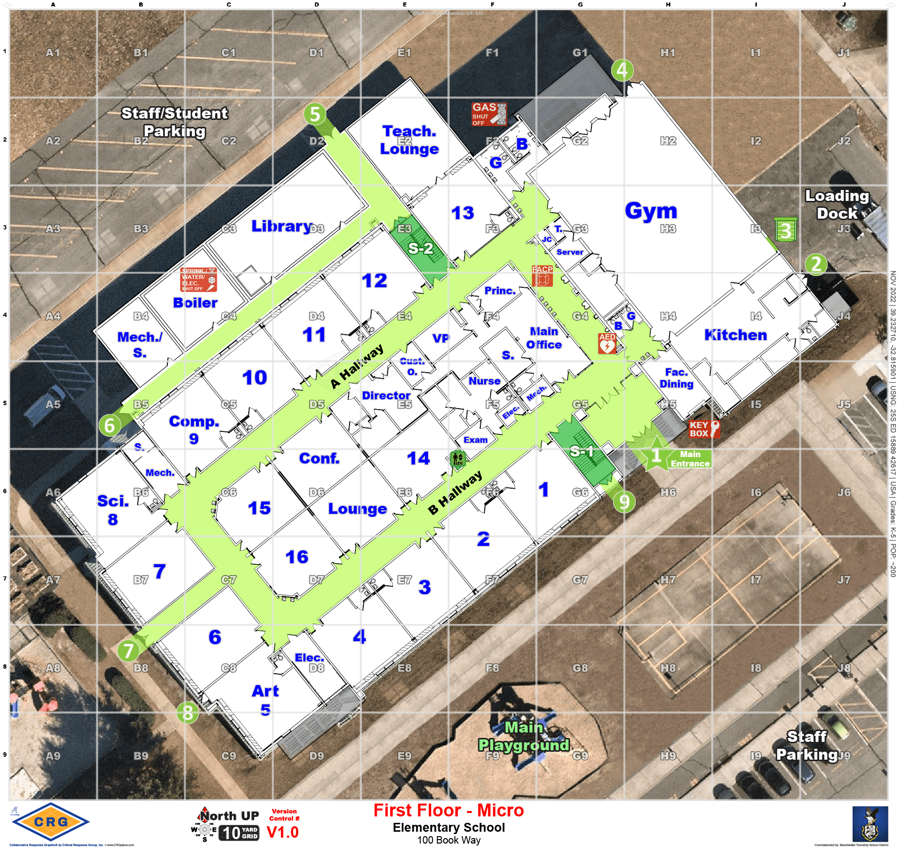
Micro™ CRGs
Built for each floor of a structure, Micro™ CRGs combine a gridded overlay with Critical Incident Mapping Data (CIMD) such as high-resolution imagery, floor plans, and building access points together into one map. Micro™ CRGs include everything that a first responder needs to know to coordinate emergency response within a structure. This includes room labels, hallway names, external door/stairwell numbers, and key utility locations.
MACRO™ CRGs
Built for a structure’s campus and grounds, MACRO™ CRGs combine a gridded overlay with Critical Incident Mapping Data (CIMD) such as current overhead imagery with accurate labeling for parking areas, athletic fields, surrounding roads, and neighboring properties. First responders and building administrators use Macro™ CRGs to coordinate crisis response external to a structure, including inner and outer security perimeters, ambulance staging areas, command posts, reunification areas, and more.
Works with CRG
Seamless Integrations
CRGs work in conjunction with a number of tools and platforms emergency response units already deploy and rely on in the field. Through these integrations, first responders are able to access CRG data on the go, and coordinate easily from their mobile devices.