Learn how Critical Response Group can streamline your application process and maximize the value of your mapping dollars with our proven approach to mapping.
Navigate Funding For Your Mapping Initiatives
Contact Our Regional Specialist

Zach Querry
School Funding Regional Specialist
Critical Response Group Meets All Michigan SB173 Criteria for Critical Incident Mapping
Providing law enforcement and first responders accurate information to help improve response time and navigate to the scene effectively. Our critical incident mapping solutions meet all Michigan SB173 criteria:
- Compatible with local, state, and federal public safety applications and technologies
- Must not require additional software
- It must be in a printable format
- Must be verified for accuracy
- Must be oriented true north
- Includes site-specific information and accurate labels that match the building’s structure
- Includes site-specific information and labels for external school grounds
- Includes accurate floor plans and aerial imagery
- Includes a gridded overlay and x/y coordinates
- Include all information to assist first responders best
Michigan’s Trusted Provider of Critical Incident Mapping Solutions
Critical Response Group is setting the gold standard of critical incident mapping and partners with and is endorsed by the Michigan Association of Chiefs of Police.
50,000
Critical Incident Maps Created Nationwide
500
School Districts Mapped in Michigan
2,500
Schools Mapped in Michigan
75
Major Counties Mapped
Integrating With the Tools Michigan Universities and Community Colleges Trust
Our critical incident mapping solutions seamlessly integrate into the technology platforms educational institutions across Michigan deploy and trust, which ensures that our maps are always there when needed.
Still Have Questions?
Here are some answers to the most commonly asked questions.
What are critical incident mapping solutions and how do they work?
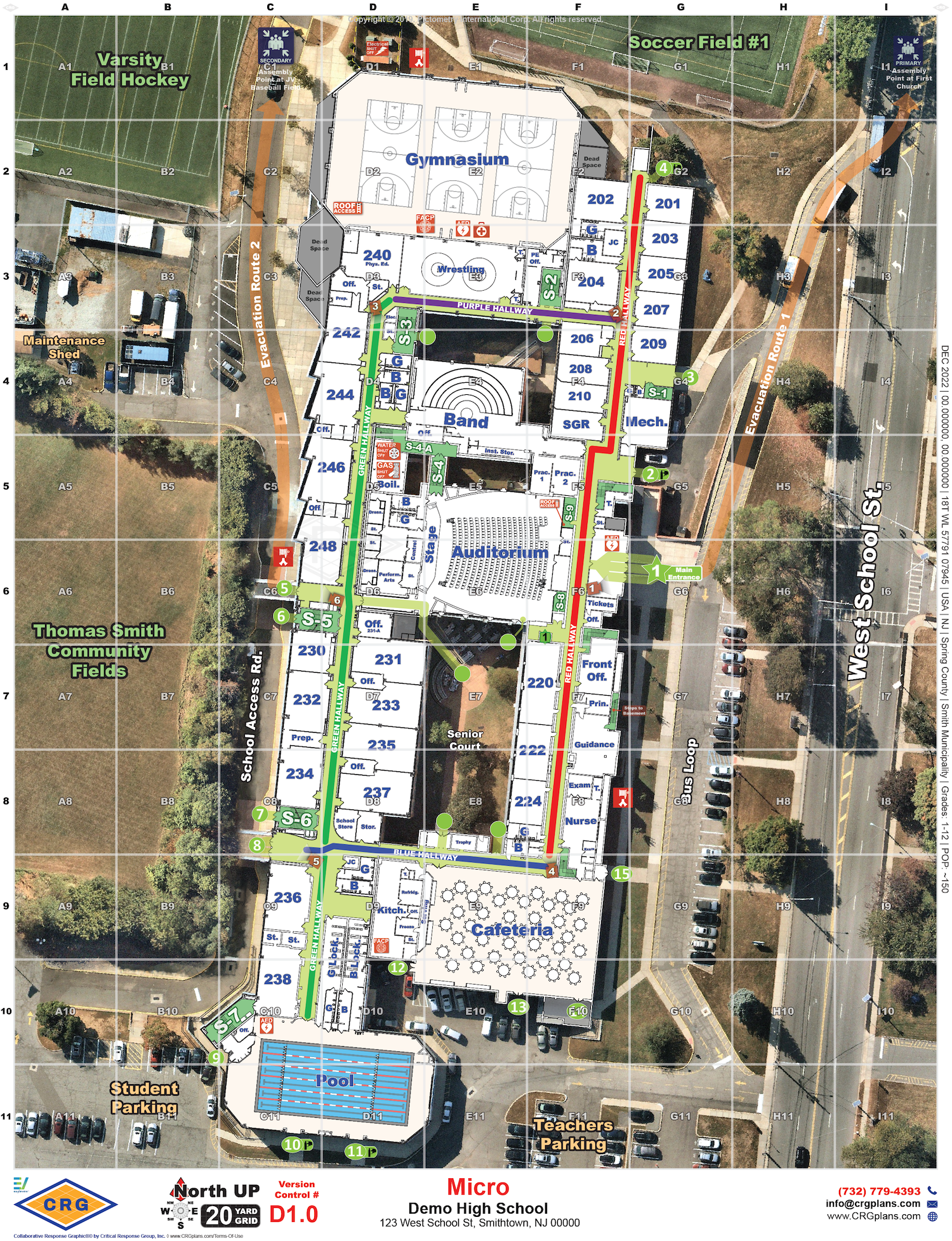
Critical incident mapping solutions, which we often refer to as Collaborative Response Graphics® (CRGs), combine a gridded reference system, high-resolution imagery, floor plans, and critical features to create accurate and real-life depictions of facilities and their surroundings. By providing law enforcement and first responders with crucial information, they enhance response time and help navigate the scene efficiently.
What criteria must critical incident mapping solutions meet according to Michigan SB173?
According to Michigan SB173, critical incident mapping solutions must meet the following criteria:
Compatibility with local, state, and federal public safety applications and technologies.
- No requirement for additional software.
- Printable format.
- Verified accuracy.
- True north orientation.
- Inclusion of site-specific information and accurate labels matching the building’s structure.
- Inclusion of site-specific information and labels for external school grounds.
- Accurate floor plans and aerial imagery.
- Gridded overlay and x/y coordinates.
- Inclusion of all information to assist first responders effectively.
Who benefits from critical incident mapping?
Critical incident mapping benefits both law enforcement and educational institutions. For law enforcement, critical incident mapping enables coordination and collaboration, resulting in faster response times and decisive actions during crises. Universities and community colleges can enhance their emergency preparedness with critical incident mapping, ensuring efficient action plans and minimizing response time.
Who is eligible for critical incident mapping funds in Michigan?
Michigan SB173, included in House Bill 6012, provides funding for critical incident mapping solutions for universities and community colleges.
Do you have successful case studies of critical incident mapping implementation?
Yes, there have been successful case studies in various states and districts. For example, Wisconsin schools received $5 million in funding for critical incident mapping data, Delaware and New Jersey had all of their public and private schools mapped and Virgina has had over 90% of their schools mapped by Critical Response Group.
Ready to Apply for Michigan SB173?
Maximize the value of your grant dollars with the expertise of CRG and our proven approach to critical incident mapping. Let us help you through the process.