West Virginia schools can meet the new requirements of House Bill 3166 with confidence – Critical Response Group simplifies the process and delivers standardized mapping data that improves emergency response and campus safety.
Navigate Funding For Your Mapping Initiatives
Contact Our Regional Specialist

Zach Querry
Regional Director
Critical Response Group is an Industry Leader of Collaborative Response Graphics
West Virginia House Bill 3166 mandates that each county board of education develop standardized school safety mapping data for all public school facilities. The data must be compatible with public safety systems and approved by local law enforcement before implementation.
CRG’s Collaborative Response Graphics® are fully compliant and meet all HB 3166 standards:
Be in formats that conform to, integrate with, and are accessible within software platforms used in local public safety answering points and by the city, county, state, and federal public safety agencies that could provide emergency services at the school without requiring the purchase of additional software or payment of fees to access the data
- Be in formats capable of being printed, shared electronically, and, if requested, digitally integrated into interactive mobile platforms in use
- Be viewable and printable from open-source document or image viewers
- Be created, stored, and maintained exclusively within the United States for the entire duration of the mapping process and thereafter to ensure security of the data
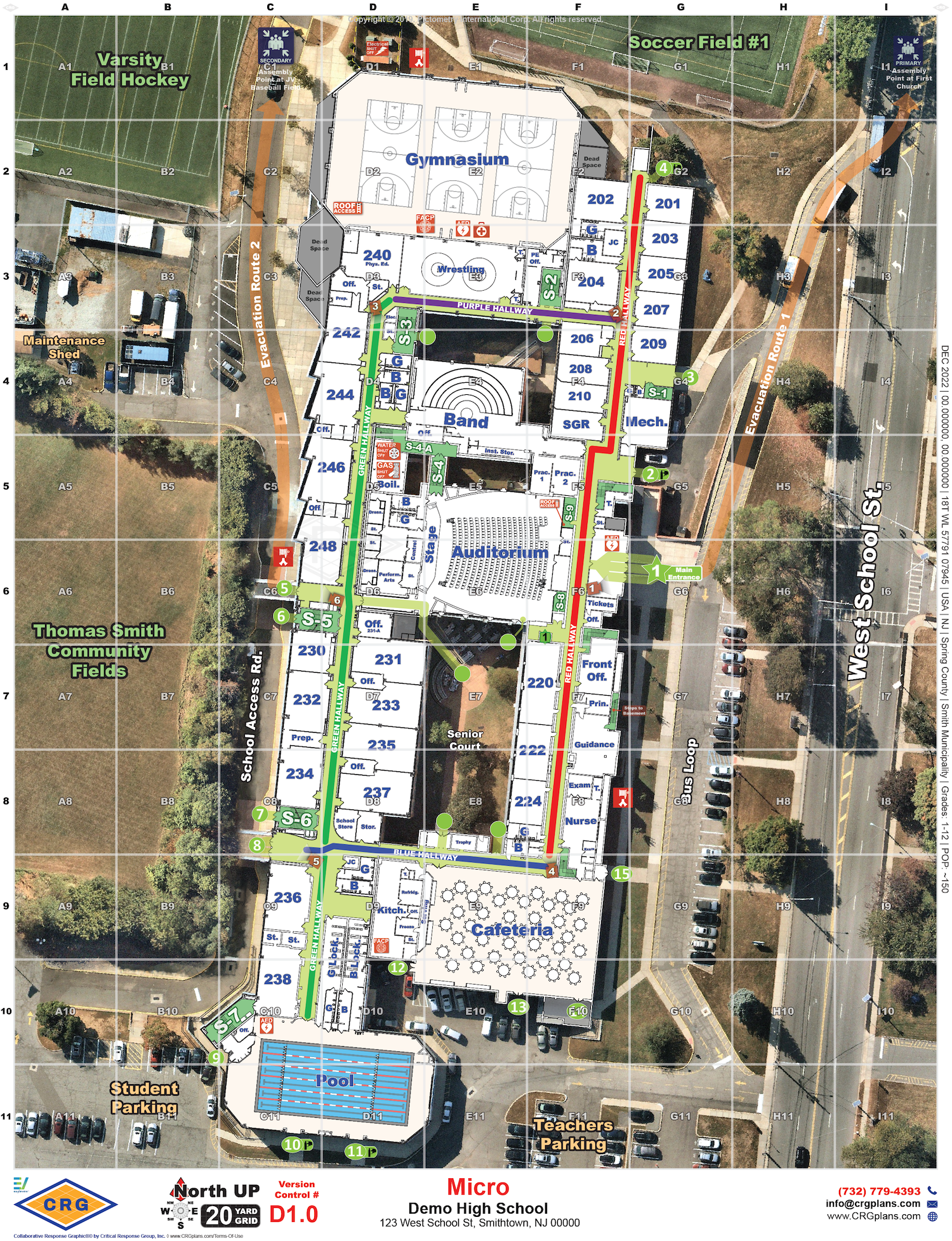
- Be oriented to true north and include a fixed grid with consistent “x” and “y” coordinates
- Have its accuracy verified by the entity producing the data through an on-site walk-through of the school buildings and grounds
- Include accurate floor plans overlaid on current, verified aerial imagery of the school campus
Include site-specific labeling for school structures, such as room names, hallway designations, exterior doors, stairwell numbers, and the locations of hazards, critical utility controls, key boxes, automated external defibrillators, and trauma kits and school grounds, including parking areas, athletic fields, surrounding roads, and neighboring properties
- Include the requirement that future updates or modifications to the school mapping data conform to and integrate with software platforms used by the relevant public safety agencies
West Virginia’s Trusted Provider of School Safety Mapping Data
Critical Response Group is setting the gold standard for school safety mapping data across the country, and partners directly with and is endorsed by the West Virginia Sheriffs’ Association.

50,000
Crisis Response Maps Created
150
School Districts Mapped in Virginia
2,000
Schools Mapped in Virginia

Integrating With the Tools West Virginia Schools Trust
Our collaborative response graphics seamlessly integrate into the technology platforms educational institutions across West Virginia deploy and trust, which ensures that our maps are always there when needed.
Still Have Questions?
Here are some answers to the most commonly asked questions.
What are collaborative response graphics and how do they work?
Collaborative Response Graphics® (CRGs), combine a gridded reference system, high-resolution imagery, floor plans that are verified by a on-site walk through, and critical features to create accurate and real-life depictions of facilities and their surroundings. By providing law enforcement and first responders with crucial information, they enhance response time and help navigate the scene efficiently.
Why is an onsite walk-through essential for collaborative response graphics?
The only way to verify accuracy of a school map is to walk-through the entire site and make changes and updates as needed. Schools change every year – structurally, in the labeling of rooms, and in the locations of critical items like AEDs and cameras. Floor plans for the building are often not kept up with these changes. First responders describe location over the radio by what they see, so maps need to match the layout and labeling of the facility. Maps also need to capture how students and staff naturally talk about locations around the building – even if it is not on a sign on the wall or labeled on blueprints – as they will use this language when describing their location under stress. All this data can be only captured during an in-person site visit.
Who benefits from collaborative response graphics?
Collaborative response graphics benefit both law enforcement and educational institutions. For law enforcement, collaborative response graphics enable coordination and collaboration, resulting in faster response times and decisive actions during crises. Educational institutions can enhance their emergency preparedness with collaborative response graphics, ensuring efficient action plans and minimizing response time.
Who is required to submit collaborative response graphics in West Virginia?
Under West Virginia House Bill 3166, each county board of education is mandated to develop standardized school safety mapping data for all public school facilities within their jurisdiction. This requirement applies to all public schools across the state.
Before initiating the mapping process, county boards must consult with and obtain formal approval from their primary law enforcement agency. This ensures that the mapping data aligns with local emergency response systems and meets the operational needs of first responders.
Once finalized, the mapping data must be provided—at no additional cost—to the following entities:
The West Virginia State Board of Education
The Division of Homeland Security and Emergency Management
Local first response agencies, including police, fire, and emergency medical services (EMS)
Any other local entities identified by the school’s crisis response planning team
The deadline for compliance with these requirements is September 1, 2026.
Do you have successful case studies implementing collaborative response graphics?
Yes, there have been successful case studies in various states and districts. For example, Wisconsin schools received $5 million in funding for crisis response mapping data, Delaware and New Jersey had all of their public and private schools mapped and Virgina has had over 90% of their schools mapped by Critical Response Group.
Ready to Get Started on Your School Safety Mapping Data?
With over 50,000 emergency response maps deployed nationwide – CRG is ready to help West Virginia schools meet HB 3166 requirements quickly and effectively.