Georgia schools can meet HB 268 requirements with confidence—Critical Response Group simplifies the grant process and delivers school mapping data that strengthens emergency response and campus safety.
Navigate Funding For Your Mapping Initiatives
Contact Our Regional Specialist

Stephen Herold
Regional Director
Critical Response Group Meets All Requirements of Ricky and Alyssa’s Law for School Mapping Data
Giving first responders the accurate data they need—our school mapping solutions are built to improve response times and meet every requirement of the program:
- Be in formats that conform to and integrate with software platforms utilized in local public safety answering points and by local, state, and federal public safety agencies that respond to emergencies at schools and that do not require such agencies to purchase additional software or provide payment in order to view or access such data.
- Be in formats capable of being printed, shared electronically, and, if requested, digitally integrated into interactive mobile platforms.
- Be verified for accuracy each year by the entity producing such school mapping data by means of an in-person inspection of each school.
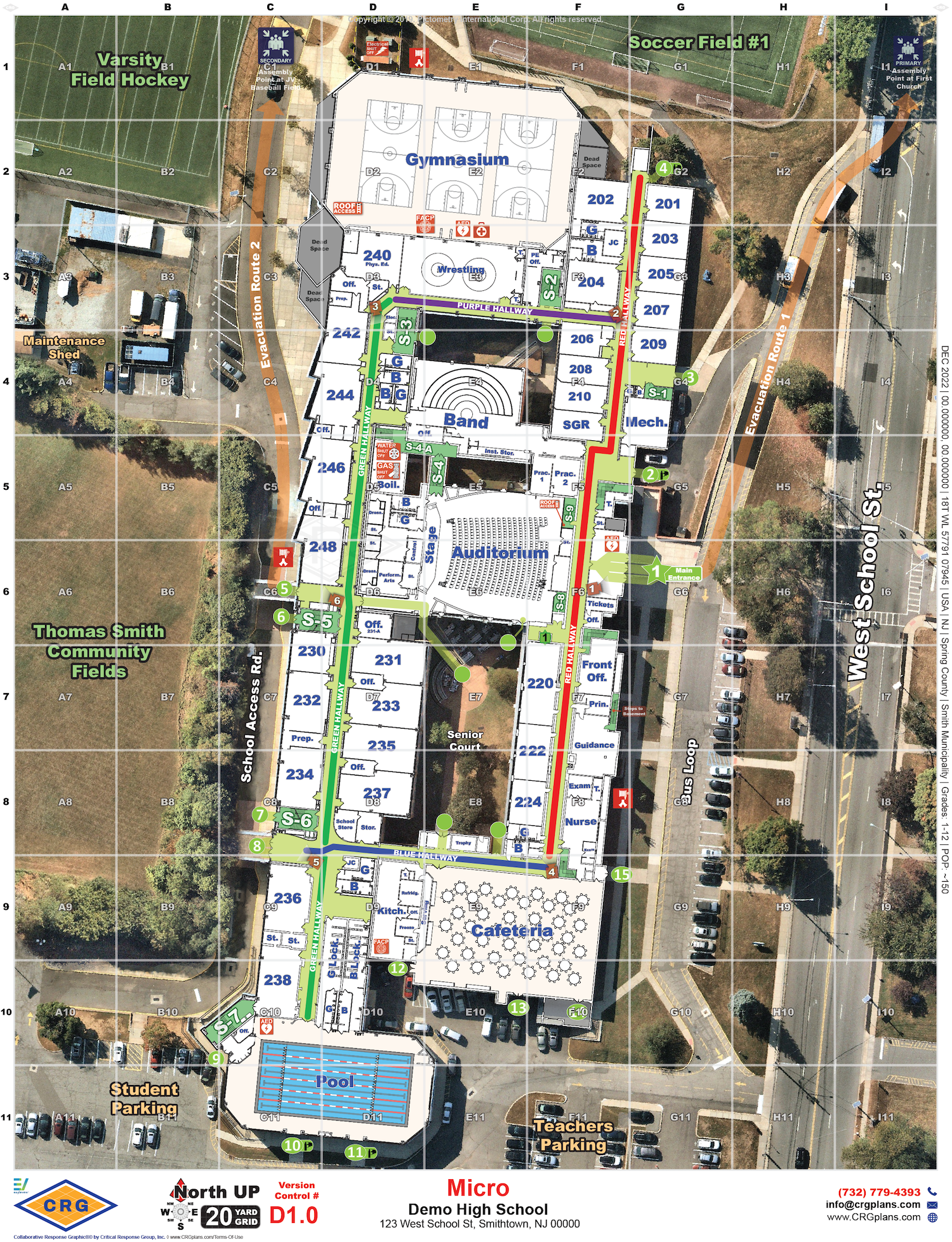
- Identify and label access points of each building interior, including, but not limited to, rooms, doors, stairwells, and hallways, each of which shall include any identifiers or names utilized by staff and students.
- Identify and label locations of critical utilities, key boxes, automated external defibrillators, and trauma kits or other emergency response aids.
- Identify and label areas at or near each school, including parking areas, athletic fields, surrounding roads, outbuildings, and neighboring properties.
Georgia’s Trusted Provider of Collaborative Response Graphics®
Critical Response Group is setting the gold standard for school mapping data across the country, and partners directly with and is endorsed by the Georgia Association of Chiefs of Police.
50,000
Maps created nationwide
500
Schools Mapped in Georgia
5,000
Schools Mapped in the Southeast
Integrating With the Tools Georgia Schools Trust
Our collaborative response graphics seamlessly integrate into the technology platforms, panic buttons and camera systems educational institutions across Georgia deploy and trust, which ensures that our maps are always there when needed.
Still Have Questions?
Here are some answers to the most commonly asked questions.
What are collaborative response graphics and how do they work?
Collaborative Response Graphics® (CRGs), combine a gridded reference system, high-resolution imagery, floor plans that are verified by a on-site walk through, and critical features to create accurate and real-life depictions of facilities and their surroundings. By providing law enforcement and first responders with crucial information, they enhance response time and help navigate the scene efficiently.
Why is an onsite walk-through essential for school mapping data in Georgia?
The only way to verify accuracy of a school map is to walk-through the entire site and make changes and updates as needed. Schools change every year – structurally, in the labeling of rooms, and in the locations of critical items like AEDs and cameras. Floor plans for the building are often not kept up with these changes. First responders describe location over the radio by what they see, so maps need to match the layout and labeling of the facility. Maps also need to capture how students and staff naturally talk about locations around the building – even if it is not on a sign on the wall or labeled on blueprints – as they will use this language when describing their location under stress. All this data can be only captured during an in-person site visit.
Who benefits from school mapping data?
School mapping data can benefit both law enforcement and educational institutions. For law enforcement, school mapping data can enable coordination and collaboration, resulting in faster response times and decisive actions during crises. Educational institutions can enhance their emergency preparedness with school mapping data, ensuring efficient action plans and minimizing response time.
Who is required to submit school mapping data in Georgia?
Every public school in Georgia is required to procure school mapping data by July 1, 2026, as outlined in Georgia House Bill 268. Local school systems must work with their primary law enforcement agency to verify that all mapping data aligns with emergency response requirements set by the Georgia Emergency Management and Homeland Security Agency.
Do you have successful case studies implementing school mapping data?
Yes, there have been successful case studies in various states and districts. For example, Wisconsin schools received $5 million in funding for school mapping data, Delaware and New Jersey had all of their public and private schools mapped and Virgina has had over 95% of their schools mapped by Critical Response Group.
Ready to Get Started on Your Collaborative Response Graphics?
Maximize the value of your dollars with the expertise of CRG and our proven approach to school mapping data. Let us help you through the process.