With more states recognizing the value of verified maps in emergency response, school safety grants have become a critical tool for funding district-wide mapping initiatives. From newly created state programs to competitive grant opportunities, schools now have access to funding specifically designated for indoor mapping technologies that improve situational awareness and accelerate emergency response.
What Are School Safety Grants and How Do They Fund Emergency Mapping Projects?
School safety grants are public funds distributed at the state or federal level to support initiatives that improve emergency preparedness. Increasingly, these grants include (and often prioritize) indoor mapping solutions that help first responders navigate schools quickly and effectively during a crisis.
To qualify for funding, most mapping projects must meet clear operational and technical criteria, including:
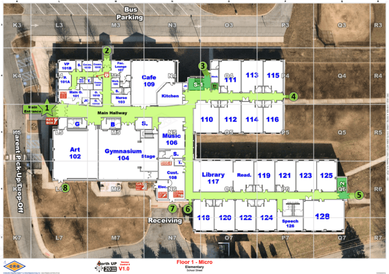
- Field-verified walkthroughs to ensure every space, hallway, and access point is accurately documented
- Clear labeling of rooms, doors, access points, and life safety assets for quick decision-making under pressure
- Multi-agency usability, including law enforcement, fire, EMS, and school resource officers
- Format compatibility with public safety systems like CAD, 911, and dispatch, without requiring proprietary software
These requirements are designed to ensure that the maps funded through these grants are more than digitized floorplans. They are fully functional tools that support real-time decision-making during emergencies.
Eligible applicants typically include public school districts, charter schools, private schools, and public safety agencies working in partnership with schools.
How State-Funded School Safety Grants Differ from Federal Programs
Federal programs like the STOP School Violence Act offer broad safety funding, but state-level grants often take a more focused approach, especially when it comes to funding for emergency mapping.
Many state programs are shaped by recently passed legislation that outlines specific mapping criteria, timelines, and reporting requirements. These grants often emphasize local agency coordination, public safety system compatibility, and direct support for mapping deliverables—not just general safety upgrades. As a result, state funding is frequently better aligned with the needs of first responders and may provide more targeted opportunities for schools looking to implement or upgrade their mapping systems. CRG actively monitors these state-level developments and tailors our mapping process to meet the exact specifications of each program.
Explore Emergency Mapping Grant Opportunities by State
CRG actively tracks funding programs that include emergency mapping. See if your state has a current or pending program:
State Grant Available
Public K-12 school districts are eligible for school mapping data funds under Florida House Bill 301.
State Grant Available
Public K-12 school districts are eligible for school mapping data funds under HB 268.
State Grant Available
Public K-12 school districts are eligible for crisis response mapping data funds under Illinois Section 50 legislation.
State Grant Available
School corporations, accredited private schools, charter schools and coalitions of school corporations are eligible for critical incident digital mapping funds under Indiana House Bill 1492.
State Grant Available
Public, private and charter schools are eligible for a school mapping data grant through the School Mapping Data Program under Kentucky Senate Bill 2.
State Grant Available
All public and charter schools are eligible for funds through the state mandated School Safety Data Mapping Program under HB 0472.
State Grant Available
Public, intermediate and nonpublic K-12 school districts are eligible for crisis response mapping data funds under Michigan 97d legislation.
State Funding Available
All universities are eligible for critical incident mapping funds under Michigan SB173.
State Grant Available
Public and charter schools are eligible for grant money through the School Emergency Response Mapping Fund under LB 1329.
State Funding Available
Boards of education and chief administrators of nonpublic schools are required to provide critical incident mapping data for all schools to local law enforcement authorities under New Jersey Senate Bill 2426.
State Funding Available
All K-12 School districts and open-enrollment charter schools should provide DPS with accurate emergency response maps under Texas House Bill 3.
State Funding Available
Local school boards are required to make a collaborative response graphic for every public school building as part of their yearly safety audits under Virginia Legislation 22.1-279.8.
State Grant Available
Each county board of education develop standardized school safety mapping data for all public school facilities as mandated by the West Virginia House Bill 3166.
State Grant Available
Every public and private school is required to submit blueprints to local law enforcement. All schools are eligible for crisis response mapping data funds under Wisconsin Act 109.

How CRG Helps Schools Secure Mapping Grants
At Critical Response Group, we don’t just create maps—we help schools secure the funding to make them possible. Our team works closely with school districts and public safety agencies to identify available grant opportunities, interpret eligibility requirements, and ensure all deliverables meet state and federal funding standards.
From the first consultation to final implementation, CRG provides:
- Guidance on grant eligibility and submission timelines
- Pre-written documentation aligned with mapping legislation
- Technical specs and formats required by state funding programs
- Templates and talking points for joint applications with law enforcement
- Ongoing support during audits, reimbursement, and compliance reviews
CRG has supported over 600 school districts in navigating school safety funding programs. Our mapping solutions have been approved through grant programs in over a dozen states with deliverables trusted by law enforcement, school administrators, and 911 professionals alike.
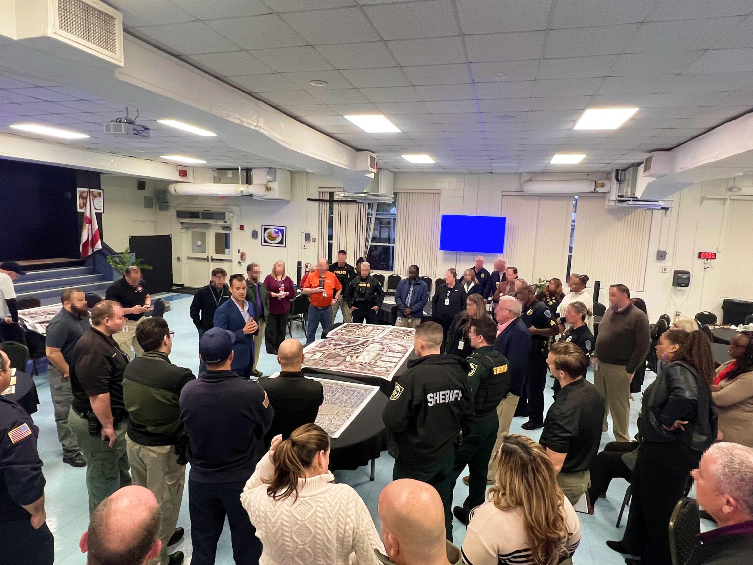
Partnering with Law Enforcement and Districts Across the U.S.
Our work starts on the ground—with walkthroughs of every hallway, classroom, and access point—and ends with operational maps built for real-world use. CRG’s team is composed of domestic public safety experts and former operational leaders, bringing firsthand experience in law enforcement, fire service, and emergency management to every project.
Our mapping solutions are built by practitioners, for practitioners and tailored to your state’s funding requirements and formatted for seamless use within the systems your teams already rely on.
Whether your school is responding to new legislation or proactively applying for grant funding, CRG ensures you’re ready, with maps that meet every requirement and partners who understand every step of the process.
Frequently Asked Questions About School Safety Grants for Mapping
What types of school improvements are eligible under state safety grants?
Many state safety grants now focus on tools that improve emergency preparedness and response. This includes verified indoor mapping solutions that help first responders quickly navigate school campuses during a crisis. In several states, emergency mapping is a required component of funded safety plans.
Are school mapping technologies covered under school safety grants?
Yes. Increasingly, school safety grants specifically include funding for critical incident mapping data, especially when maps meet criteria outlined in state legislation, such as on-site verification, public safety system compatibility, and first responder accessibility.
Do all states offer school safety funding for mapping?
Not all states have active mapping grant programs, but many do, and the number is growing. States like Florida, Texas, Michigan, and New Jersey have passed legislation or launched grant programs specifically supporting school emergency mapping. CRG maintains a state-by-state database of current and pending opportunities.
Who can apply for a school safety grant focused on mapping?
Eligibility varies by state, but typically includes public school districts, charter schools, private schools, and law enforcement agencies partnering with schools. Some programs require joint applications to ensure mapping deliverables meet first responder needs.
How can CRG help with securing and implementing school mapping grants?
CRG provides end-to-end support. We help schools identify applicable funding, interpret eligibility requirements, draft required documentation, and deliver grant-compliant mapping solutions, backed by public safety experts who understand the process.
How much funding is typically available for school mapping projects?
Funding amounts vary by state and program. Some offer flat per-school awards (e.g., $3,000–$5,000), while others provide competitive grants based on district size or need. CRG can help estimate costs and align your mapping proposal with available funding.
Is Your State Not Listed?
Let’s Collaborate.
Use the experts at CRG to help drive legislative action for your state or discover alternative funding sources that might be available.