Effective emergency response starts long before the call comes in.
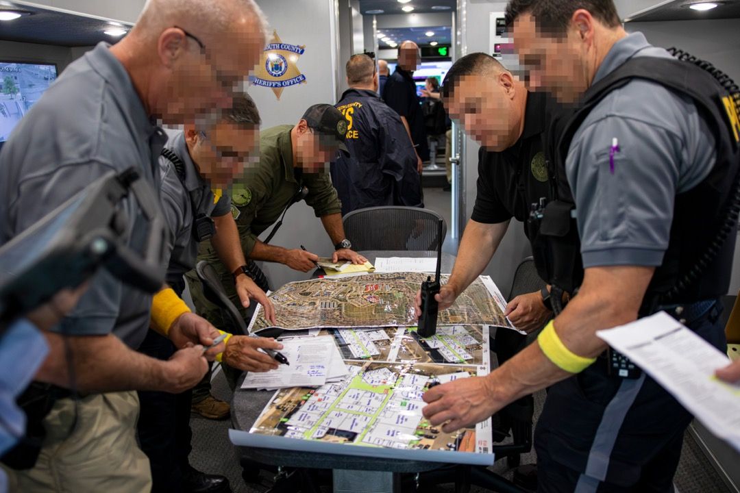
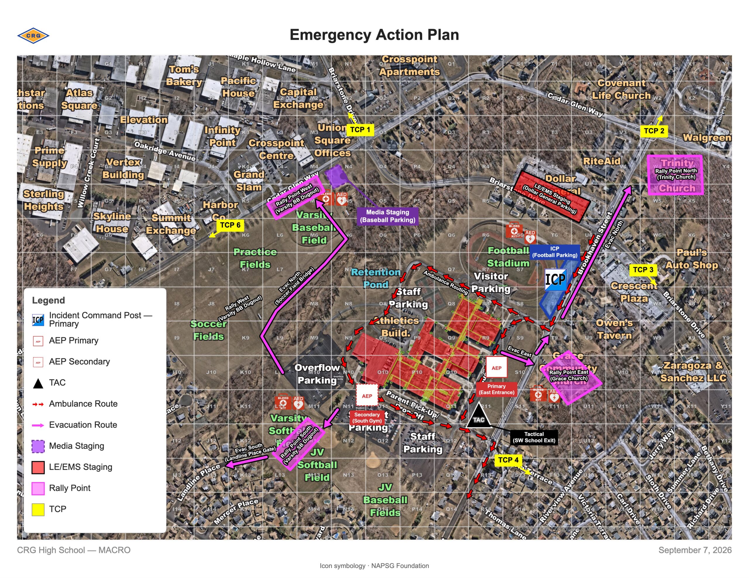
Public safety agencies routinely plan where incident command will be established, where responders will stage, how emergency vehicles will access a site, where evacuees or families may be directed, and how multiple agencies will coordinate during a complex incident or planned event.
One challenge with pre-incident planning is that plans, maps and response systems are often developed independently. A plan may identify a staging area or evacuation route on one map, while dispatchers, incident commanders and responding personnel use another geographic reference when the plan is activated.
Building pre-incident plans on the same responder-ready maps used during an actual response can help close that gap and give agencies a consistent common operating picture from preparedness through response.
What Is Pre-Incident Planning?
Pre-incident planning is the process of identifying important operational information before an emergency or planned event occurs so responders have a stronger starting point when a plan is activated.
Depending on the facility, event or scenario, agencies may identify:
- Incident command posts
- Responder staging areas
- Casualty collection and triage locations
- Reunification sites
- Access and traffic control points
- Security and operational zones
- Perimeters and sectors
- Evacuation and emergency vehicle routes
- Mutual-aid coordination points
- Agency-defined resources
The specific elements will vary by agency and scenario. Planning them in advance gives responders and incident commanders an established operational framework that can be adjusted as conditions change.
Why Should a Common Operating Picture Start Before an Incident?
A common operating picture gives public safety agencies a shared geographic reference for understanding locations and coordinating operations. That shared reference can be just as valuable during planning as it is during response.
Consider a staging area identified months before an event. If that location exists only in a standalone emergency plan, responders may need to locate and communicate it again using the systems available to dispatch and incident command. Mutual-aid partners who did not participate in the planning process may also be working from a different map.
The same challenge can apply to command posts, access points, evacuation routes, operational zones and other critical locations.
Using a consistent geographic reference across planning, dispatch, command and field response helps agencies carry information developed during preparedness into the operational environment where it will be used.
Building Pre-Incident Plans on Responder-Ready Maps
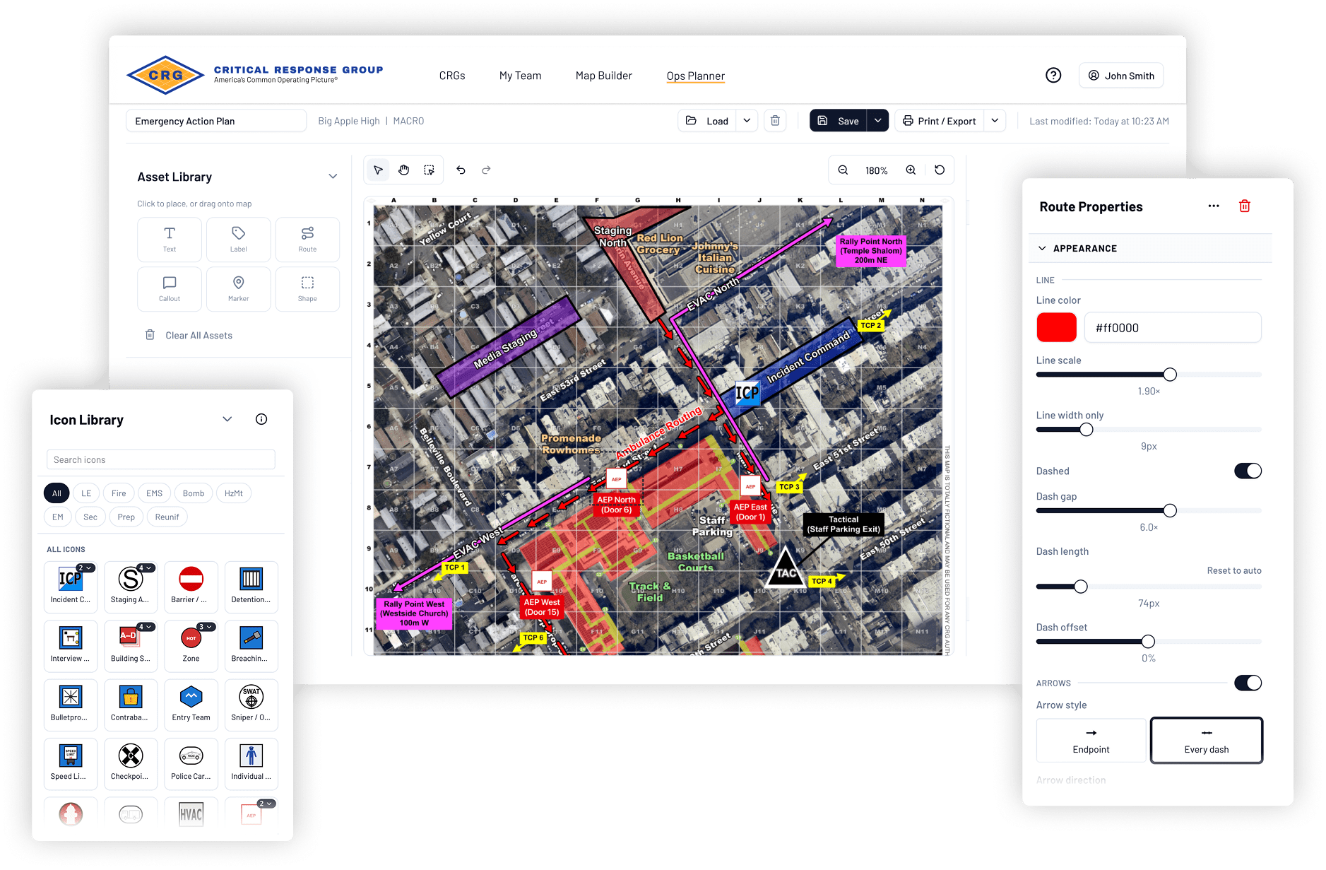
Critical Response Group (CRG) developed Ops Planner to extend the common operating picture agencies use during emergency response into the planning process.
Ops Planner allows police, fire, EMS, 911, SWAT and emergency management teams to build operational plans directly on their existing Collaborative Response Graphics® (CRGs®).
CRGs are field-verified, responder-ready maps developed specifically for emergency response. More than 100,000 CRGs have been produced nationwide, providing responders with a standardized geographic reference across thousands of facilities and communities.
With Ops Planner, agencies can build operational plans directly on existing CRGs and:
- Establish planned operational locations on the same maps responders already use
- Add agency-specific information and resources for different scenarios or events
- Create a shared geographic reference for police, fire, EMS, 911 and emergency management
- Prepare plans that can support both emergency incidents and planned events
- Carry planning information into the systems and workflows used during response
Building plans on existing CRGs allows agencies to use the same responder-centric mapping foundation during preparedness that can be available to responders when the plan is activated.
How Can Pre-Incident Planning Support Emergency Response?
Pre-incident planning helps agencies prepare for complex emergencies by identifying potential operational needs and locations before responders arrive on scene.
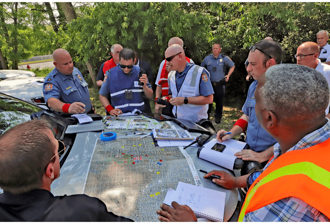
For an active-threat incident, agencies may pre-plan command and staging locations, access routes, operational zones and reunification areas.
For a mass-casualty incident, planners may identify casualty collection and triage locations, emergency vehicle routes and areas for coordinating incoming mutual-aid resources.
These plans provide an operational starting point that incident commanders can adapt as an event unfolds.
How Can Agencies Use Pre-Incident Planning for Special Events?
Pre-incident planning can also support stadium events, large public gatherings and other planned operations that require coordination among multiple agencies.
Law enforcement, fire, EMS, 911, emergency management and other partners may need to establish command locations, security zones, staging areas, traffic management points, emergency vehicle routes, access control and mutual-aid coordination before an event begins.
In summer 2026, the technology behind Ops Planner was used to support public safety planning surrounding FIFA-related events in New Jersey, demonstrating its application in a complex, multi-agency event environment.
For planned events, establishing this operational geography in advance gives participating agencies a shared reference before operations begin.
Why Does Interoperability Matter in Pre-Incident Planning?
Interoperability helps agencies carry geographic information developed during planning into the systems and workflows used during response.
Emergency operations often involve multiple systems. Dispatchers may work in CAD and 911 platforms, while emergency managers use GIS or situational awareness systems. Incident commanders and responders may rely on additional command-and-control and response platforms.
CRGs are delivered in interoperable formats that integrate with CAD, 911, GIS, emergency management, situational awareness and command-and-control platforms.
Using a consistent geographic reference across these systems can help dispatchers, incident commanders and responding disciplines maintain a common understanding of locations throughout an operation.
How Does a Shared Map Support Multi-Agency Coordination?
A shared geographic reference helps agencies communicate more consistently about locations during complex and mutual-aid operations.
A major incident may bring together law enforcement, fire, EMS, emergency management, 911 personnel and specialized teams from multiple jurisdictions. Some responders may know the facility well, while others may be seeing it for the first time.
Using a common geographic reference gives participating agencies a consistent way to communicate about command posts, staging areas, routes, access points, zones and other operational elements.
When that same reference is used during pre-incident planning, the geographic information established before an operation can carry forward when multiple agencies respond.
Getting More Value From Existing Critical Incident Mapping
Thousands of communities across the country have invested in building and field-verifying CRGs, and public safety agencies have incorporated those maps into their response systems and operating procedures.
Pre-incident planning extends the value of that mapping into preparedness.
Agencies can use the same mapping foundation to develop emergency action plans, prepare for special events and coordinate with partner agencies before an operation begins.
Ops Planner is available at no cost to eligible public safety agencies wherever CRGs have been deployed, allowing agencies to build operational plans on their existing mapping foundation without purchasing an additional planning platform.
 Frequently Asked Questions About Pre-Incident Planning
What is pre-incident planning in public safety?
Pre-incident planning is the process of identifying and documenting important operational information before an emergency or planned event occurs. Agencies may pre-plan command locations, staging areas, access points, evacuation routes, traffic control, reunification locations and other operational elements so responders have an established framework when the plan is activated.
What should a public safety pre-incident plan include?
A public safety pre-incident plan may include incident command posts, responder staging areas, casualty collection and triage locations, evacuation and emergency vehicle routes, reunification sites, access and traffic control points, operational zones, perimeters, sectors and mutual-aid coordination needs. The specific elements depend on the location, agency and type of operation.
Why should pre-incident plans use the same maps as emergency responders?
Using the same mapping foundation for planning and response helps agencies maintain a consistent geographic reference when a plan is activated. Dispatchers, incident commanders, responders and mutual-aid agencies can use that shared reference to understand planned locations and coordinate operations.
What is a common operating picture in public safety?
A common operating picture is a shared operational view that helps different agencies and disciplines understand locations and coordinate their actions. Collaborative Response Graphics provide a standardized, field-verified geographic reference designed for emergency response and integration with the public safety systems agencies already use.
How does pre-incident planning support mutual-aid response?
Responders arriving through mutual aid may be unfamiliar with a facility or community. Building plans around a shared geographic reference can help agencies communicate command locations, staging areas, routes, access points, operational zones and other critical locations across jurisdictions.
Can pre-incident planning be used for special events?
Yes. Pre-incident planning can support stadium events, large public gatherings and other planned operations involving multiple public safety agencies. Agencies can establish command, staging, traffic management, access control, emergency routes and other operational elements before an event begins.
What is CRG Ops Planner?
CRG Ops Planner is an operational planning capability that allows public safety agencies to build emergency action plans, special-event plans and other pre-incident plans directly on existing Collaborative Response Graphics. It extends the common operating picture used during emergency response into preparedness and planning.
Who can use CRG Ops Planner?
Ops Planner is designed for public safety agencies, including police, fire, EMS, 911, SWAT and emergency management teams. It is available at no cost to eligible public safety agencies in communities where CRGs have already been deployed.
How much does CRG Ops Planner cost?
Ops Planner is available at no cost to eligible public safety agencies wherever CRGs have been deployed. Agencies can use their existing CRGs as the foundation for pre-incident planning without purchasing an additional planning platform.
Build Plans on the Same Maps Responders Use
Pre-incident planning gives agencies an opportunity to establish critical operational information before an emergency or planned event begins. Using the same responder-ready mapping foundation across preparedness and response helps keep that information consistent from planning through field response.
Learn how your agency can get started with Ops Planner.
Eligible public safety agencies can use Ops Planner at no cost wherever CRGs have been deployed.