Your school’s CRG map was built to provide an accurate, verified picture of your campus when it matters most. That same mapping foundation can support a much broader range of needs across the school year, giving staff an accurate starting point for the maps they create for everyday operations, events, planning and communication.
Consider how often someone in your district needs to create a map.
A facilities director needs to communicate a construction closure. An administrator is planning testing locations. The front office needs a visitor map for an upcoming event. Athletics wants to show parking and entrances for Friday night’s game. A safety team is updating an evacuation plan. Staff are preparing for student orientation, graduation or summer programming.
These projects are often owned by different people, in different departments, for entirely different audiences. Yet they all depend on the same underlying information: an accurate representation of the school and campus.
Without a shared mapping workflow, staff often turn to whatever resource is easiest to find at the time.
How Many Versions of Your School Are Floating Around?
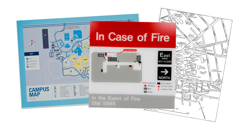
Most schools already have plenty of maps. They may also have plenty of versions of those maps, scattered across departments, software platforms and individual staff members.
One person has an old floor plan saved to their desktop. Another department created a version in PowerPoint. Someone else rebuilt the campus in Canva for last year’s open house. Facilities has a more current drawing, but the person creating the next event map may not know it exists.
Over time, those individual projects create a larger challenge. A room changes use. An entrance is updated. Construction affects a route. A portable classroom is added. Parking patterns change. Meanwhile, older maps continue to live in shared drives, presentations, PDFs and design files, making it increasingly difficult to know which version reflects the campus today.
For schools that already have CRG mapping, Map Builder provides a common starting point. Authorized staff can use the school’s existing CRG map as the foundation for additional maps they need throughout the year, keeping those efforts connected to the same trusted mapping data.
One Mapping Foundation, Many Teams
The potential value becomes much larger when access extends beyond the people who traditionally work with emergency planning. Mapping needs exist across the district, and many staff members encounter them throughout the year.
Safety and Security Teams
Safety teams may be the most familiar map users within a school. Their needs can include evacuation plans, drill materials, reunification layouts, assembly areas, staging locations and other preparedness resources.
Common Mapping Needs:
- Fire evacuation and emergency exit maps
- Emergency reunification maps
- Shelter-in-place and severe weather planning
- Lockdown and internal security planning
- Emergency drills and exercises
- Emergency operations and responder staging
Starting with verified mapping data gives these teams a consistent foundation as plans evolve and new materials are created.
Facilities and Operations
Facilities teams regularly manage changes to the physical environment, which creates an ongoing need to communicate where things are happening and how people should move around them.
Construction may close an entrance or hallway. Maintenance work may temporarily restrict access to part of a building. Weather can affect entrances and traffic patterns. Summer projects can create temporary routes that only exist for a few weeks.
Common Mapping Needs:
- Construction zones and temporary closures
- Maintenance work areas
- Custodial cleaning and assignments
- Snow and severe weather access
- Utility and infrastructure references
- Renovation and temporary routing
Map Builder gives facilities and operations staff a familiar campus foundation they can use to communicate these changes clearly.
School and District Administrators
Administrators encounter mapping needs throughout the academic calendar, particularly when activities change the normal use of a building.
Standardized testing can require special room assignments, proctor locations and adjusted traffic patterns. New-student orientation may involve routes between key locations. Parent-teacher conferences, open houses and other school-wide activities can bring families and visitors into parts of the building they may have never visited before.
Common Mapping Needs:
- Standardized testing room assignments
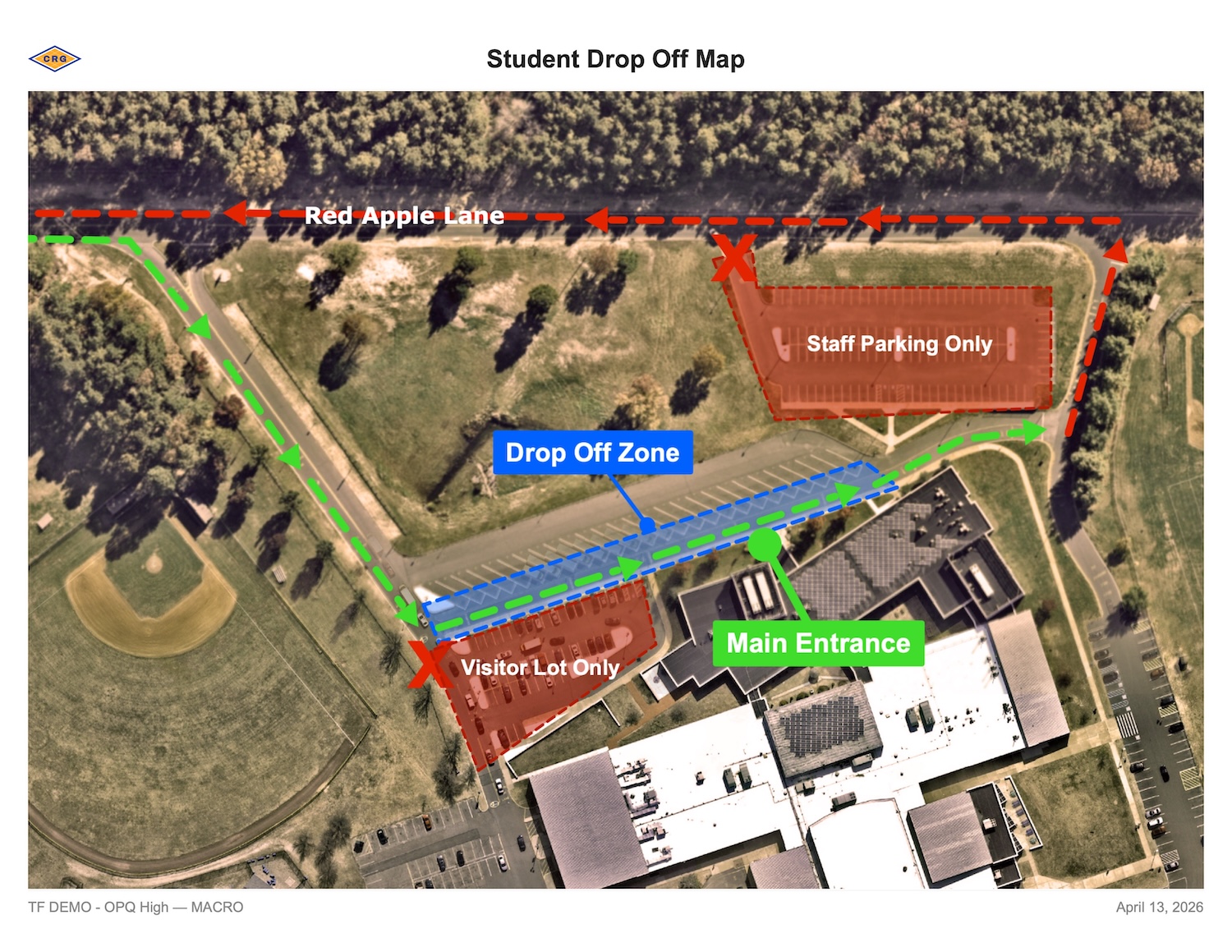
- Parent pickup and drop-off traffic flow
- Department and administrative offices
- Parent-teacher conferences
- Open houses and school-wide events
- New student orientation
Access to Map Builder gives administrators a ready starting point for these projects and reduces the need to track down a usable floor plan each time.
Athletics and Extracurricular Programs
A campus can operate very differently during a game, tournament, performance or community event.
Athletic departments may need to communicate spectator parking, entrances, fields, locker rooms, seating areas or team access points. Extracurricular programs may need similar resources for performances, competitions, festivals and other events.
Common Mapping Needs:
- Game day parking and spectator access
- Athletic facilities and locker rooms
- Tournaments and competitions
- Graduation ceremonies
- Band and performing arts events
- School festivals and community events
Each map can be tailored to the people attending and the information they need while drawing from the same underlying campus data.
Front Office and Communications Staff
Many school maps serve a simple but important purpose: helping someone understand where to go.
Visitor parking, designated entrances, check-in areas and walking routes can all be communicated visually. Maps can support school tours, volunteer events, community programs and other occasions when people who are unfamiliar with the campus need clear directions.
Common Mapping Needs:
- Visitor entrances and parking
- School tours and campus navigation
- Volunteer check-in and assignments
- Parent and community events
- New family orientation
- Visitor check-in and reception areas
For communications and front-office teams, access to Map Builder also makes it easier to create these resources directly rather than searching across departments for an existing map that might work.
Teachers, Program Leaders and Other Staff
Mapping needs can surface almost anywhere in a school.
Summer programs may operate in only part of a building. After-school programs may use different entrances and pickup locations. A temporary classroom relocation may change where students need to go. A special event may require designated activity areas, staff stations or restricted spaces.
Common Mapping Needs:
- Substitute teacher orientation
- Classroom and teacher assignments
- Temporary classroom relocations
- Summer school and enrichment programs
- After-school programs and pickup locations
- Special schedules and student navigation
Any one of these may be a relatively small project. Across a district and an entire school year, they add up to a significant number of maps created by a wide range of people.
A Consistent Foundation for Different Maps
Schools rely on different maps for different needs, with each one designed to give a specific audience the information that matters to them.
A parent arriving for an event needs a simple view of parking, entrances and check-in. A facilities employee may need much more operational detail. A testing-day map may focus on room assignments and movement through the building, while an evacuation map has an entirely different purpose.
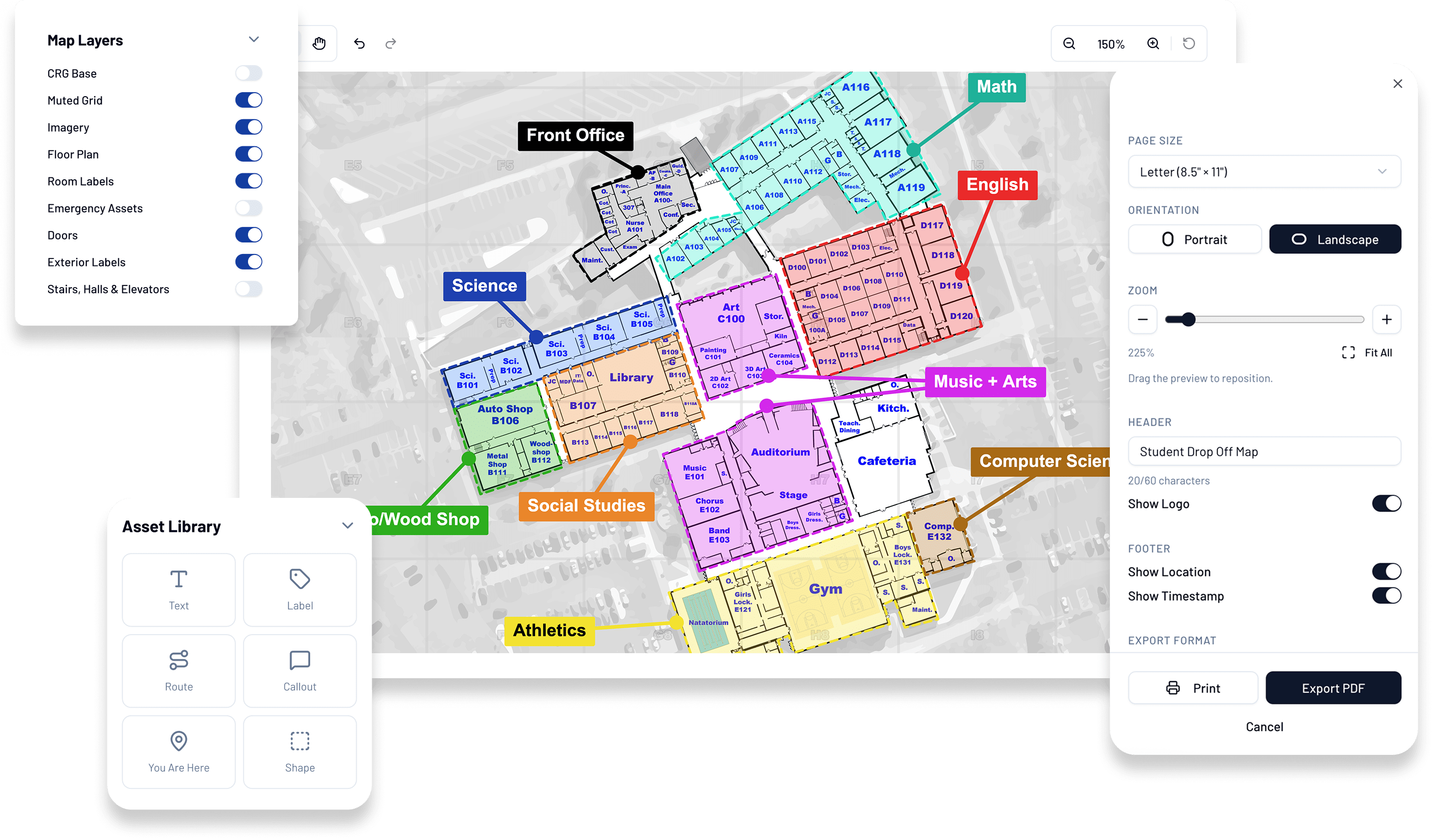
Map Builder allows each of those resources to be created for its specific use while maintaining a consistent foundation underneath. Staff can begin with the school’s CRG mapping data, add the information relevant to their project and create a map that works for the intended audience.
This also creates a more manageable process as school facilities change. Maintaining an accurate mapping foundation gives staff a reliable place to begin the next time a map is needed, reducing dependence on old PDFs, PowerPoints, Canva files and other one-off versions that may continue circulating long after they were created.
Get More From the CRG Mapping You Already Have
Schools invest in verified mapping because accuracy matters. Map Builder extends the usefulness of that investment across more departments, more staff members and more moments throughout the school year.
Schools create and update maps throughout the year, often in response to needs that are temporary, highly specific or owned by different teams. Map Builder gives those efforts a consistent place to start, extending the value of the verified CRG mapping schools already have into the day-to-day work happening across the district.
A trusted mapping foundation that can be maintained over time allows schools to spend less time tracking down old files or recreating campus information and more time building the maps they need with confidence.
With Map Builder, that foundation becomes an ongoing resource for the people across your district who create and use maps every day.
Learn more about the endless possibilities of Map Builder.
What types of maps can schools create with Map Builder?
Schools can use Map Builder for a wide range of safety, operational and event needs, including evacuation and reunification planning, parent pickup and drop-off, construction zones, visitor orientation, athletics, open houses, graduation, staff assignments and other school-specific uses. Maps can be customized for the audience and purpose while using the school’s existing CRG mapping data as the foundation.
Who at a school or district can benefit from Map Builder?
Map Builder can support staff across safety and security, facilities, administration, athletics, communications and other operational teams. Because different users can create maps for different purposes from the same verified mapping foundation, districts can establish a more consistent approach across departments and locations.
Does creating a map in Map Builder change the CRG used by first responders?
No. Map Builder allows schools to create customized maps without changing what first responders see in the school’s CRG.
Why use Map Builder instead of creating a school map in PowerPoint or Canva?
Map Builder starts with the field-verified building footprints, room labels, door numbers and interior layouts already found in a school’s CRGs. That gives staff a consistent, accurate foundation for creating purpose-specific maps rather than independently recreating the physical campus for each project.
Is Map Builder included for existing CRG customers?
Yes. CRG Map Builder is included for all active CRG customers at no additional cost and is accessible through the CRG Portal.
Map Builder is already included for all active CRG customers at no additional cost.
No new software, no extra account — just log in to the CRG Portal and start building today.