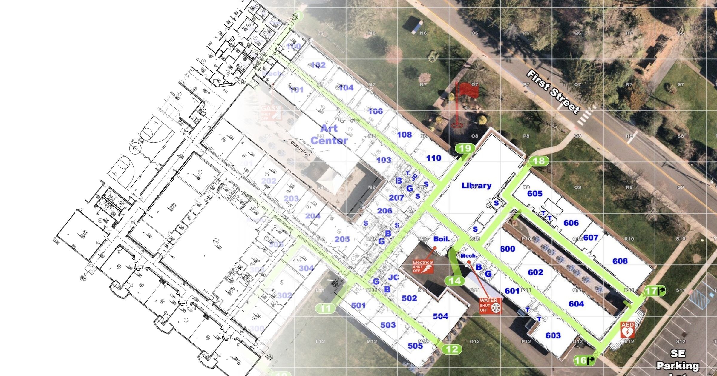
School districts evaluating emergency mapping solutions will hear a growing list of technical terms: GIS, georeferencing, CAD integration, indoor mapping, digital floor plans and public safety interoperability.
Those capabilities matter.
But simply calling a school map “digital” or “GIS-based” does not mean it is ready for emergency response.
For district leaders, the more important question is whether the mapping data is accurate, georeferenced, verified in the field, understandable to first responders and accessible through the systems public safety agencies actually use.
Understanding those distinctions can help school leaders evaluate GIS school safety maps based on how they will perform during a real incident, not simply how they look during a product demonstration.
What Is a GIS School Safety Map?
A GIS school safety map connects information about a school building or campus to an accurate geographic location.
GIS stands for Geographic Information System. GIS technology is used to organize, manage and display information based on where something exists in the physical world.
For school safety, GIS can help connect indoor building information, such as classrooms, hallways, doors and critical assets, to the larger geographic environment around the school.
That geographic foundation is important because emergency response does not stop at the building entrance.
Dispatchers and responders may need to understand how an incident inside a school relates to exterior access points, roads, parking lots, athletic fields, neighboring properties, staging areas and other locations across a campus.
Well-designed GIS emergency mapping connects those environments into one usable operating picture.
What Does “Georeferenced” Mean?
A georeferenced school map is positioned accurately within real-world geographic coordinates.
In practical terms, georeferencing ensures that the building represented on the map corresponds to where that building, and its features, actually exist on the earth.
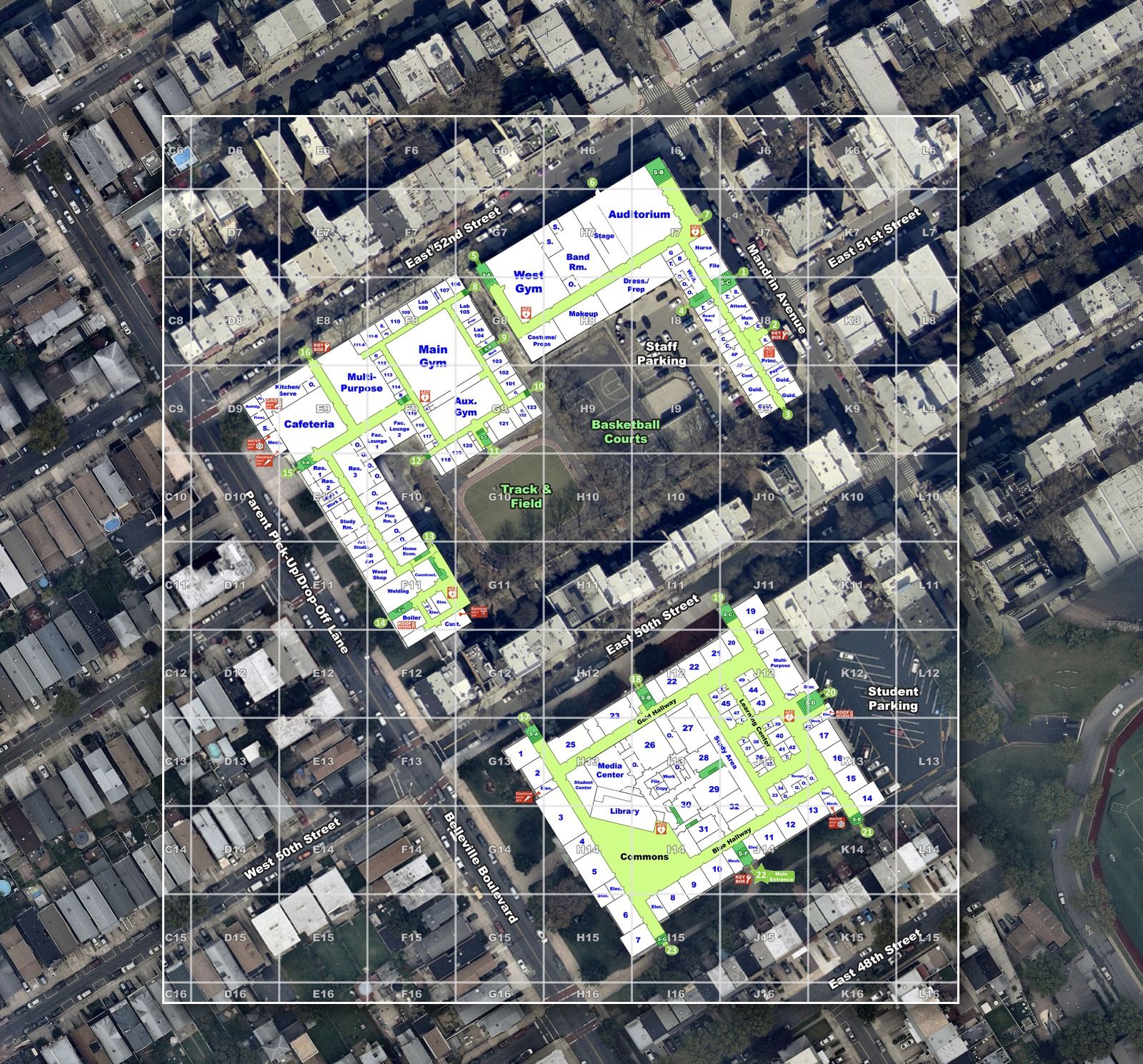
This distinction matters because a digital floor plan can still be little more than an electronic drawing.
A PDF of an architectural blueprint may show the shape of a building, for example, but that does not necessarily mean the floor plan has been correctly aligned to its real geographic location.
When indoor maps are properly georeferenced, they can work more effectively alongside the other location information used by GIS, 911 and public safety systems.
That creates a stronger connection between what is happening inside the building and the responders approaching it from outside.
Digital Does Not Automatically Mean Responder-Ready
A common mistake in emergency mapping procurement is treating “digital” as a measure of operational readiness.
It is not.
A map can be available on a computer or mobile device and still be difficult to use during an emergency.
A digital map may still contain:
- Outdated room numbers
- Doors that no longer exist
- Missing additions or renovations
- Labels that do not match what staff use on campus
- Inaccurate building footprints
- No connection between interior and exterior geography
- No standardized way to communicate a precise location
- Information that is unavailable within responder systems
Those shortcomings may not be obvious when reviewing a map from an office.
They can become much more significant during a critical incident.
For district leaders, the better procurement question is not, “Is the map digital?”
It is, “Can a dispatcher and first responder actually use this map to understand and communicate location information during an emergency?”
Field Verification Matters
Even the best source files can become outdated.
Schools change continuously. Classrooms are repurposed. Walls are added or removed. Door numbers change. Building additions are completed. Security equipment moves. Temporary spaces become permanent.
That is why on-site verification is a critical part of producing responder-ready emergency maps.
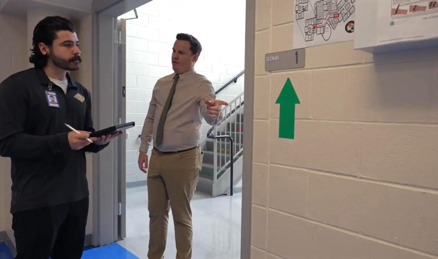
A field walkthrough allows mapping professionals to compare source information with the actual facility and validate details that cannot always be confirmed from existing drawings.
That can include:
- Room and hallway labels
- Exterior door numbering
- Stairwells and access points
- Building additions or modifications
- AEDs and other emergency equipment
- Utility shutoffs and key infrastructure
- Campus landmarks and exterior features
The principle is straightforward: emergency response maps should represent the building that exists today, not simply the building shown on the last available drawing.
Why GIS Emergency Mapping Matters to 911 and Dispatch
During an emergency, accurate location information often begins at the 911 center.
The caller may know exactly where the emergency is occurring in everyday terms: a specific classroom, entrance, cafeteria, gym (new gym vs old gym) or field.
The challenge is translating that information into something dispatchers and responding units can immediately understand.
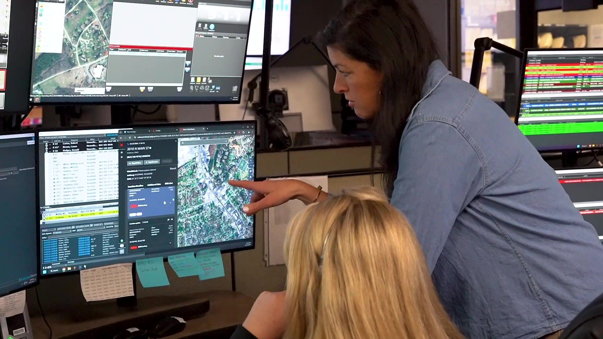
GIS-enabled emergency mapping can provide a richer geographic reference for that process.
When accurate indoor mapping data can be incorporated into public safety and 911 environments, dispatchers may be able to view detailed facility information alongside the other location data used to manage the response.
That same information can then extend into the responder workflow and creates continuity between the initial report, the dispatch process and the response on scene.
What Does CAD Integration Mean for a School District?
CAD, or computer-aided dispatch, is one of the primary systems public safety agencies use to manage calls for service and dispatch responding units.
A school district does not need to become an expert in CAD technology to evaluate emergency mapping.
District leaders should, however, ask an important question:
Can our mapping data be made available in the systems our public safety partners already use?
If the answer requires dispatchers or responders to log into a separate school-specific platform, search for a facility and navigate unfamiliar software during an incident, the district should understand that limitation.
Responder-ready mapping should reduce steps rather than create new ones.
Because technologies vary among jurisdictions, interoperability also matters. A mapping solution should not be valuable only when a particular police department, 911 center or school district uses one specific technology vendor. The data should be capable of moving across the public safety ecosystem.
Why Standardization Is Important
Individual schools often have their own naming conventions. One building may refer to an entrance as “Door A,” another as “Main Entrance,” and a third as “Entrance 1.” A district may also have maps created at different times by different architects, facilities teams or safety vendors. All of that variability creates another challenge for emergency response.
Responder-ready school mapping should establish clear, repeatable conventions that can be understood across facilities and jurisdictions.
Standardization can apply to:
- Building and floor identification
- Exterior doors
- Stairwells
- Interior rooms and hallways
- Grid coordinates
- Symbols and critical features
- Map orientation
- Interior-to-exterior references
The objective is to translate site-specific knowledge into a consistent visual system that both school personnel and outside responders can understand.
Accessibility Is Part of Interoperability
An accurate GIS map provides limited value if the right person cannot access it during an emergency. District leaders should therefore evaluate not only how mapping data is created but also where it can be used.
Ask whether the mapping solution can be incorporated into systems used by:
- 911 centers and Public Safety Answering Points
- Law enforcement
- Fire and EMS
- Emergency management agencies
- School safety and security teams
- Emergency notification platforms
- Public safety mobile applications
- GIS environments
An interoperable approach allows the same trusted mapping foundation to appear across different tools without forcing every participant to adopt a single proprietary platform.
That distinction becomes especially important for districts that interact with multiple law enforcement, fire or EMS agencies.
What Should District Leaders Look for in GIS School Safety Maps?
When comparing emergency mapping vendors, school leaders should look beyond the phrase “GIS-enabled” and evaluate the complete process.
A responder-ready mapping solution should address five fundamental questions:
1. Is the map accurately georeferenced?
Indoor and exterior mapping information should correspond to its real geographic location and support integration with GIS and public safety systems.
2. Has the facility been physically verified?
An on-site walkthrough should confirm that maps reflect current conditions instead of relying entirely on existing drawings or remotely collected information.
3. Can first responders understand it quickly?
Maps should use consistent orientation, intuitive labels and standardized visual references designed for communication under stress.
4. Can the data integrate with public safety technology?
Ask where the mapping data can be deployed, including CAD, 911, GIS, emergency management and first responder platforms.
5. Is access dependent on a proprietary application?
Determine whether responders need separate software, credentials or licenses to see the maps—or whether the data can be incorporated into the systems they already use.
Taken together, these questions help districts distinguish between a digital representation of a school and operational mapping data designed for emergency response.
How Collaborative Response Graphics® Apply GIS to Emergency Response
Critical Response Group creates Collaborative Response Graphics®, or CRGs, to establish a common operating picture for organizations and their public safety partners.
CRGs combine field-verified floor plans, aerial imagery, a standardized grid, site-specific labels and critical response features into a visual format designed to be understood under stress.
The mapping data is georeferenced and designed for integration across GIS, 911, CAD, mobile public safety, security and emergency management environments.
That system-agnostic approach means the value is in the mapping data itself, not in requiring every responder to adopt another standalone application.
For school districts, the result is a mapping foundation designed to connect the people who know the campus with the public safety professionals responsible for responding to it.
Frequently Asked Questions About GIS School Safety Maps
What is the difference between GIS mapping and a digital floor plan?
A digital floor plan is an electronic representation of a building layout. GIS mapping associates information with real-world geographic locations. For emergency response, GIS-enabled indoor mapping can connect building details with the surrounding geographic environment and public safety systems.
What does it mean for a school map to be georeferenced?
A georeferenced school map is accurately positioned within real-world geographic coordinates. This helps align indoor building information with exterior maps, GIS data and location-based public safety technologies.
Why should school emergency maps be field verified?
Existing floor plans and facility records can contain outdated or incomplete information. Field verification confirms room labels, entrances, stairwells, building changes and other critical features against the actual facility.
Do GIS school safety maps integrate with 911 systems?
They can, depending on the mapping format, available integrations and technology used by the local 911 center. Districts should specifically ask mapping providers how their data can be integrated with 9-1-1, first responder, and GIS systems.
Is a digital school map enough for emergency response?
Not necessarily. A responder-ready map should also be accurate, current, georeferenced, field verified, easy to understand under stress and accessible to the public safety agencies that may respond to the facility.
Look Beyond the Map on the Screen
School emergency mapping is about giving dispatchers and first responders reliable location information that can help them understand an unfamiliar environment and coordinate with one another when time matters.
For district leaders evaluating GIS school safety maps, that means looking beyond whether a vendor can digitize a building.
Look at how the data is created. Ask how accuracy is verified. Understand where the maps can be accessed. Involve your public safety partners and make sure the final product is designed around the people who may one day need to use it under pressure.
Download The School Leader’s Guide to Emergency Mapping Procurement for a more detailed framework for evaluating emergency mapping providers or speak with a CRG expert about building responder-ready maps for your district.